

By John Dedes,
The question of “Who discovered the Americas” will probably be a matter of debate and extensive discussion until the end of history.
- Who discovered the Americas?
- Did Christopher Columbus play the most critical role, and did he alter world history?
- Has history given enough credit to the contribution of Amerigo Vespucci?
- Is it true that without cartographers, an approach of earth zoom would not be possible, and the explorers mentioned above would have never found the new continent?
-
Are there right or wrong answers to the question of organized complexity and many factors coming together for one historical moment? Before moving forward with the article, it is significant that I already warn you that this is not a personal opinion, but rather an objective analysis that aims to ask historical questions to thoroughly examine the inquiry of who discovered the Americas.
In this part of the analysis, when it comes to the question of who discovered the Americas, we will examine the view with the earth-zooming effect while trying to understand the world’s geography.
Rather than viewing it as a personal analysis, start considering it as a way of putting together numerous observations that will help people decide and answer the question once and for all (even if the answer is not standard).
So who discovered the Americas? Before forming a thesis, let us dive deep into the factual analysis and the well-rounded factors we need to consider.
Earth Zooming Definition
Before moving to the following topic and the first part of the analysis for the question of who discovered the Americas, it will be necessary to define one phrase that will be extensively used throughout the article.
If you see the phrase “earth zoom” in the following section, please know that you will have to identify it as how the people used the maps and the cartographical evidence to zoom in on the different parts of the earth.
This is a phrase that, personally speaking, is attractive and gives us a more concise meaning
Earth Zoom is used to replace:
- “which helped the people understand the different parts of the world separately.”
- “the map provided a better explanation of the specific parts of the earth.”
- “the knowledge of people about different views and approaches.”
Who discovered the Americas – Cartography
When it comes to understanding the importance of the explorers in making sure that they have reached the new continent, it is crucial to make the case that this would have never actually been the case if it was not for the producers of maps and cartographers.
1. Tabula Rogeriana Map — 1100s Earth Zoom
Three earth-zooming cartographic productions are crucial and can contribute to our understanding of mapping the world before asking who discovered the Americas.
The first is the production of an extensively researched geographical text covering the natural, ethnic, racial, and cultural groups when it comes to the earth zooming approach and goes by Tabula Rogeriana.
It was produced for King Roger II of Sicily by the famous earth-zooming cartographer of the 1100s named Al Idrisi.
The map produced in 1154 is significant for the “who discovered the Americas” question and the approach of earth zooming because it was based on the people’s perception of the world up until this point; it divided the world and the earth zooming in seventy rectangular sections, which was the dominant view of the globe.
2. Mappa Mundi Map — 1300s Earth Zoom
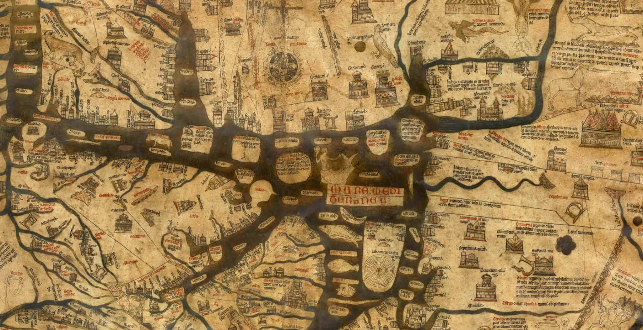
The following map, which is more connected to the period we are analyzing and the topic of who discovered the Americas, is the section of documents going by the name of “Mappa Mundi.”
The most accurate, well-known, and prominent map in the existence of global cartography up until the 1300s was Hereford Mappa Mundi.
This medieval map had crucial issues, such as the mislabeling of Africa as Europe and the opposite, putting Jerusalem at the center of the world and a view of the earth as being flat.
Regardless, it is a historical map that has influenced generations of cartography and explorations that were able to use for further research in the geography and the topography of the globe.
3. Fra Mauro Map — 1500s Earth Zoom
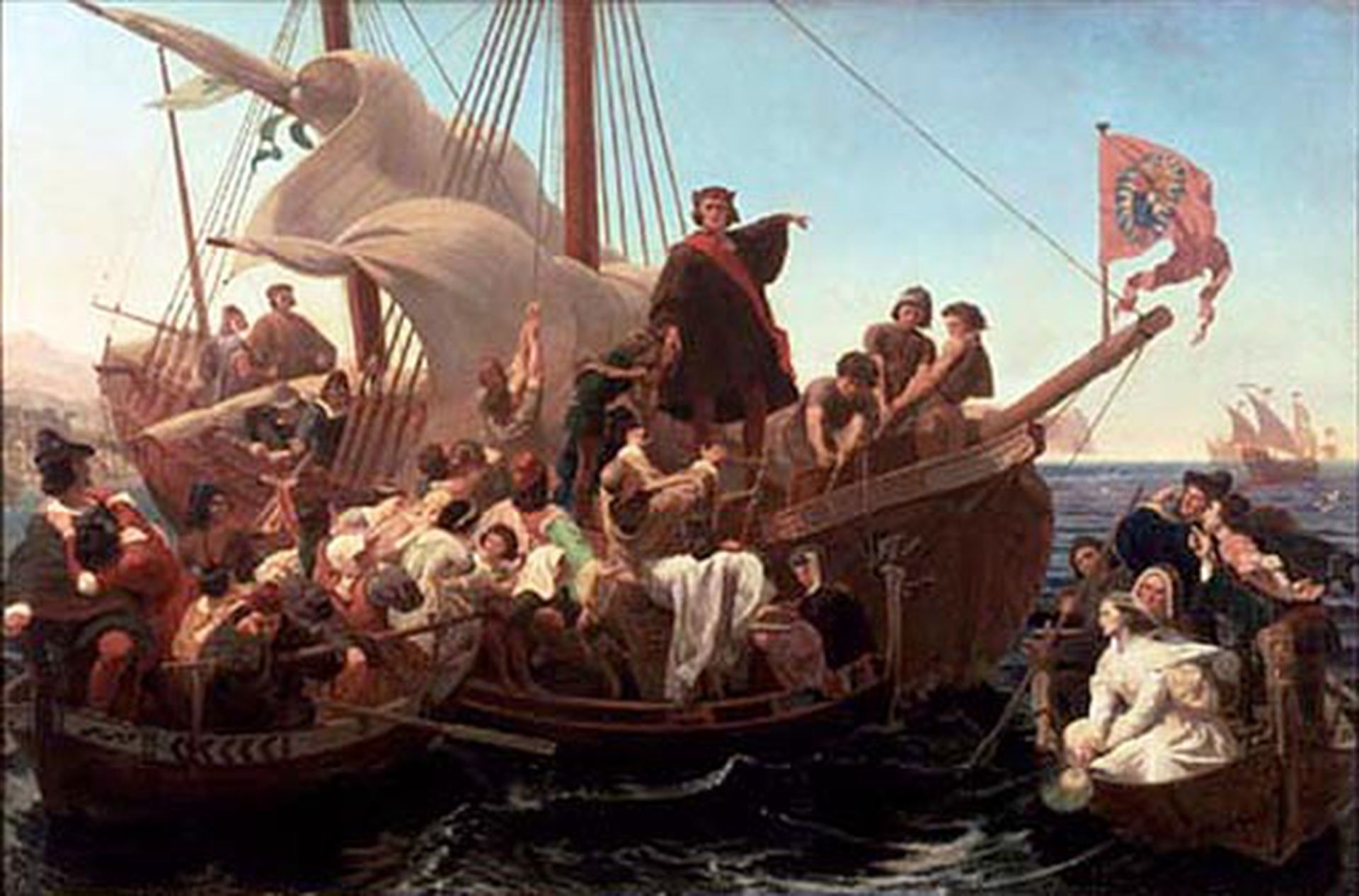
The third creation is the map directly connected to the exploring travels of Amerigo Vespucci, Christopher Columbus, their respective supporters, and fellow sailors. It makes an excellent case for the “Who discovered the Americas” question.
More specifically, this section concerns the earth-zooming Fra Mauro Map, which was created by Fra Mauro around 1450 AD.
It can be considered the most precious piece that has ever existed and belonged in the history of medieval cartography. It contributed to the earth-zooming effect of the globe for the people who lived in this era.
The Fra Mauro Map is an extensive map that best depicts the European, Asian, and African continents as far as it concerns this particular era; the 15th century.
It has been based on the Ptolemy Map of 150 AD, and as Caitlin Dempsey wrote in her article Mapping Through the Ages: The History of Cartography, published on January 29, 2011: “The Ptolemy map is notable for its potential role in the Roman expansion. Ptolemy wrote his Geographica around the year 150 AD, and refers to a system of latitude and longitude, as well as a means of describing locations on earth based on astronomical observations from those areas.”
Nonetheless, the Fra Mauro Map is based on the assumption that the Ptolemy map was no longer accurate after 1200 years. The most indicative approach of this fact is that the Ptolemy Map depicted the world’s topography, from the North to the South. In contrast, the map of Fra Mauro had a precisely opposite orientation.
4. Universalis Cosmographia — 1600s Earth Zoom
Even though this concerns a map that is contemporary to the events that the series of these articles studies, this is connected to the “who discovered the Americas” question, as well as the impact that the map had on earth zooming and the presentation of the New World.
Approximately 15 years after the new reality of hailing Vespucci and Columbus for the men who discovered the Americas and had provided a space of exploration for the Europeans up until this point, the German Cartographer Martin Waldseemüller produced the Waldseemüller Map.
The cartographical evidence, also widely known as the Universalis Cosmographia, was the first map in the history of the world to have been examined through an earth-zooming approach to the Americas.
This is a map that is also based on some earth zooming facts that were presented by the Ptolemy map.
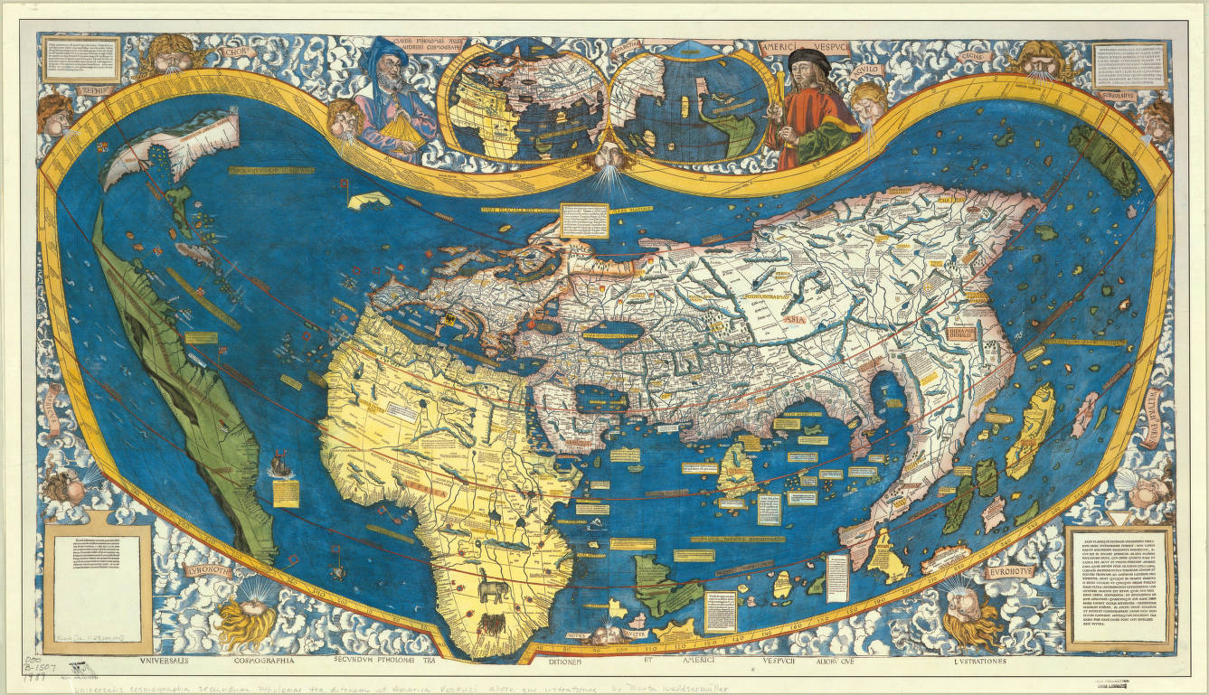
As stated by the analysis of Martin Lehmann entitled The Depiction of America on Martin Waldseemüller’s world map from 1507 — Humanistic Geography in the service of political propaganda, and published on December 31, 2016: “This land appeared here to the captain [Cabral] of the fourteen ships sent from Portugal to Calicut by the King: it was thought to be mainland [i.e., part of Asia] although, together with the previously discovered part, it is an enormous sea-girt island of yet unknown size [i.e., not part of Asia], in which both sexes, male and female, are used to going about no otherwise than as their mothers bore them. Furthermore, here they are somewhat lighter-skinned than those found on an earlier expedition under the command of the King of Castile.”
Evaluation of Cartographical Mapping — Who Discovered the Americas
It would not be surprising for a reader to think that mapping did not play a crucial role in the discovery of the Americans. More specifically, it would be justifiable to have this perception.
That is because, according to my personal views, there has yet to be much attention given to the people who were able to geographically map the world and show the explorers the possible directions and outcomes of their traveling.
The case of Amerigo Vespucci, Christopher Columbus, and the question of who discovered the Americas is a prime example of not giving enough credit to the researchers but mostly honoring the first people that were stepping their feet in the new land.
This was not necessarily about the cartographers that had mapped the world and used their work to achieve an earth-zooming effect.
For this historical analysis of the question of who discovered the Americas, an objective result is that the mapping of earth zooming, the cartographical researchers, and the people that worked extensively before and after 1492 to understand the topography of the globe had a more outstanding contribution in the discovery of the New World than the one that has been awarded to them.
References
- The Life of Admiral Christopher Columbus by His Son Ferdinand. Translated by Keen, Benjamin. Westport, CT: Greenwood Press. 1978 [1959].,
- Smith, Walter George (1906). “Christopher Columbus: An Address Delivered Before the American Catholic Historical Society”. Records of the American Catholic Historical Society of Philadelphia. 17 (4): 374–398.,
- Wey, Gómez Nicolás (2008). The tropics of empire: Why Columbus sailed south to the Indies. Cambridge, MA: MIT Press.,
- Bartlett, Richard. Great Surveys of the American West. Norman: University of Oklahoma Press, 1980.,
- Fernlund, Kevin J. William Henry Holmes and the Rediscovery of the American West. Albuquerque: University of New Mexico Press, 2000.